(December 17 – written by Dave)
Parental Warning: this post is rated Geography Nerd (GN) – stop reading now if you don’t care about plate tectonics and/or continental drift – you’ve been warned!
Of course we know where we are. We are in La Paz, BCS, Mexico and soon will be heading on the ferry from the Baja Peninsula to the “Mexican Mainland” – which brings me to first geographical question and the subject of this blog.
Nearly every traveller that we’ve met while working our way down the Baja Peninsula (including us) has talked of taking the ferry to “the mainland”. Well, this got me thinking. I’m pretty sure that for the other part of Mexico to be called the “mainland”, we’d actually have to be on an island, not a connected peninsula. I checked Webster’s and sure enough.
main·land
noun: mainland; plural noun: mainlands
- a large continuous extent of land that includes the greater part of a country or territory, as opposed to offshore islands and detached territories.
The Baja Peninsula is neither an island, nor detached.
So this week in Spanish class, I asked our instructor what Mexicans called “the mainland”. Sure enough, Mexicans know their geography – they don’t call it the mainland. They call it the “Interior de la Republica de Mexico”. They don’t shorten this to the “Interior” – they always say at least “Interior de la Republica”. Ok, now we know.
If you’re still reading, then you might be a geography nerd – thanks for sticking with me. Your leavewithoutpay junior Geography Nerd badge is being printed.
The next geographical question that’s been on my mind for some time is: When will we cross from the North American continent to the South American continent? I sort always thought that Canada, the USA and Mexico made up North America and everything south of Mexico is South America. So I did some research.
The first surprise I found online was that some people think that Mexico is actually part of South America. It is easy to see where people might be confused, Fowler’s Modern English Usage explains North America like this:
“the term ‘North America’ is mostly used to mean the United States and Canada together. Countries to the south of the United States are described as being in Central America (Mexico, Nicaragua, etc.) or South America (Brazil, Argentina, etc.)”
This is the story for many English speaking people from the USA and Canada. The people of Mexico however do see themselves as North Americans. And they are not alone. The CIA fact book – yeah, I didn’t know that they had one either – states that North America consists of “Bermuda, Canada, Clipperton Island, Greenland, Mexico, Saint Pierre and Miquelon as well as the United States”
That’s a somewhat odd list of countries that creates more questions but for Mexico at least, it is pretty clear – the leavewithoutpay editors are going with CIA (as you do) – Mexico is in North America – end of argument.
Mexico’s location solved, I moved onto the North/South question… I had always thought that plate tectonics or more specifically, the location of continental plates, would determine continental boundaries. But in looking to verify this, I found another group of folks who thought that the equator was a better dividing line for the hemispheres.
Take a look at the map below and you’ll see that this would put a whole bunch of clearly South American countries in North America. Columbia and Venezuela can simply not be part of North America. The CIA would clearly rule the equator dividing line people incorrect (and we are not going to argue with the CIA).
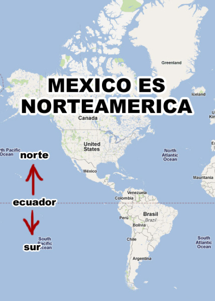
Clearly, that won’t work…
Which brings us back to the continental plates. I’ll admit that I’d never seen a map of the North and South American continental plates. I’ll share one here with readers still reading because if you’ve made it this far, well, you deserve a double gold star on your junior Geography Nerd badge – and of course the chance to see a map of western hemisphere tectonic plates.
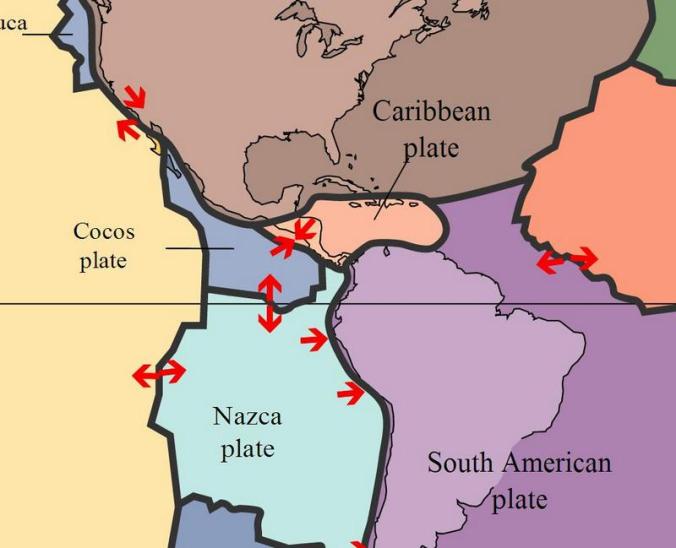
The tectonic plates
Using plates, we can clearly see that Canada, the USA and Mexico are in North America, and that Columbia, Venezuela and the rest of the near the equator countries are in South America. But from here, we have a wee bit of a problem. The brown North American plate and the purple South American plate only touch way out in the Caribbean Sea. They are separated by a small plate called the Caribbean plate covering pretty much the whole of Central America.
Places don’t have to be on a continent. Take Hawaii for example – an island out in the Pacific Ocean that seems perfectly happy being an island. But Central America is not an island, and it is connected to two contiguous land masses. It seems only right that it should be part of one continent or the other.
The plate tectonic nerds call Central America a “sub-continent”. Great, Central America now has a name but the very name, “sub” implies that it is part of something bigger. There are no obvious mountain ranges that help us. And you can’t pull out the old cultural “Latin America” is in the south trick – heck, the biggest country in South America doesn’t speak Spanish (Brazil speaks Portuguese) and we already agreed that Mexico is in North America. (No – I’m not going to look up the definition of “Latin America” because yes, I know that, Portuguese could well be included – this post was not supposed to be so difficult)
Former US president Teddy Roosevelt once said something about Central America and a big stick. I don’t think that folks in Central America were overly excited by Teddy, but at least it made me think of his grand project, the Panama Canal. I am happy to report that a good number of “internet experts” have decided that the Panama Canal, or rather, the narrow land at the Isthmus of Panama can be our dividing line between the continents. Best I can tell, they reached this conclusion because nothing else fit and like the junior geography nerds of leavewithoutpay, they had to pick something. The country of Panama gets sort of stuck between two worlds, but so does Turkey, so they just have to live with it.
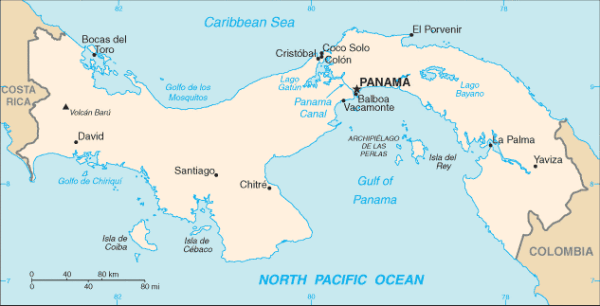
North and South division – LWOP editor’s choice
Phew, I’m exhausted now– I think I need another fish taco!
Oh yeah, one last geographical conundrum for our readers. Currently there is some sort of political uprising/block the roads/unrest in Honduras. As a result, there is a current travel warning not to go through there by both the USA and Australian governments. You can’t get through Central America (or southern North America as we now know it) without going through Honduras. After finally working out where we’d cross from north to south, we may end up hopping over to Cuba for a spin and then heading to Columbia without seeing the unofficial continental border in Panama anyway. Honduras will probably settle their issues long before we get there but just in case, if anyone can help us figure out which continent Cuba sits on, that would be splendid. (I’m not too worried about Cuba, as Cuba can always pull out the neutral “I’m an island” card if things get messy).
Leavewithoutpay junior Geography Nerd badges are in the post… honest.
Merry Christmas from Mexico, North America.
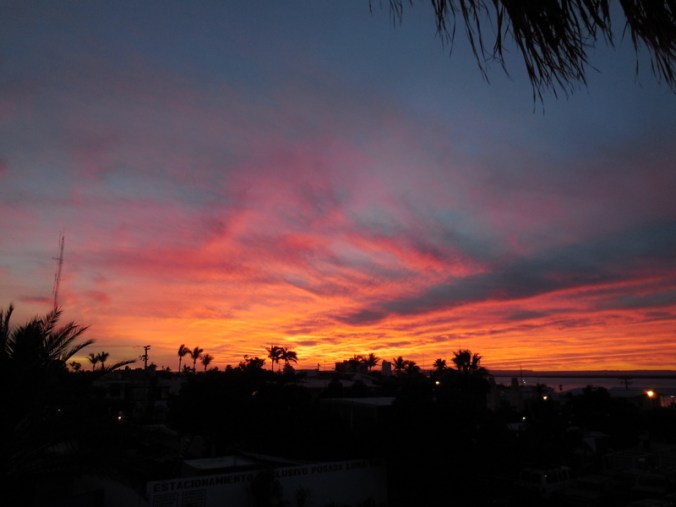
Closing La Paz sunset photo – another 80 degree day, with a few clouds to give us some color…

Mom and I read all the way to the end. Where are our badges!??!?! Also, I always have taught that Central America is a region but part of North America when I teach about the continents to my students, which is about where you ended in your exploration. If you’d asked them, you might not have needed to “bore” us with all these “interesting” details!!!
There’s that old saying in life, “when in doubt, ask a 3rd grader”.
Okay… My head hurts. Thanks for the geography lesson. Patricia and I are now on our 1-2 year adventure. Cycled from Christchurch to Queenstown. Currently in Te Anu, and leaving for a hut-to-hut backpack on the Kepler Track. Thank you for all your counsel regarding how to prepare for an extended global journey.
Congratulations on starting, that’s the hardest part.
Are you blogging?
Well, I did it.. but when i got to your ” Phwe (?) I was expelling air too!!! quite a deal I feel alot smarter.. Now I am wondering where Costa Rica is and what it is classified as….you are so smart David I don’t now jow you did that.. or was it Nancy as she is more smart!!!anyway I enjoyed the blog and will be waiting for my blogs after next week as you will be on the road again!!!that’s a good song by Willie Nelson…….Hope you have a fine Christmas with fish taco’s for dinner !!! love you AP..
Thanks AP – you’re the best!
Thanks for the geography lesson Dave! I feel much smarter now. Happy Holidays to you both!
Thanks Akemi – your office decor looked fab!
Wow. That is a lot to take in. I’m proud to say I read it all and some of it twice (a slow learner I guess). Enjoy a warm and wonderful Mexican Christmas!
No better way to recover from the excesses of Christmas Day than with an extended geography lesson. Well done, loved it! Hope you enjoyed your broiling Christmas.